The most expensive mistake in construction happens because you find out too late
Problems on a job site usually start in one place: the drawings and the actual construction have drifted apart, and nobody notices until later. A one-centimeter gap on a drawing looks trivial on paper. But once a process is well underway, it's a different story. Whether you change the design or undo what's already been built, the moment you touch it, both cost and schedule get pushed back. In the rare case where you have to strip out concrete and pour it again, the price jumps several times over.
On top of that, job sites are simply too large and too fast-moving. An inspection covering hundreds of thousands of square meters, done by a person with a tape measure and their own eyes, can only ever be a sample. You can't see everything, so discrepancies grow quietly in the places nobody looked. And that discrepancy always surfaces late, after the cost has already grown. The most expensive mistake in construction isn't the wrong material. It's finding out about a discrepancy too late.
This is exactly where drones and AI are changing things. From the earliest stages of a project — putting up retaining walls, compacting to the planned elevation, driving piles — the site gets looked down on from above every day, and that day's construction gets checked against the design. They see what people were missing, and catch discrepancies on the spot. What used to grow expensive because it was caught late now gets caught early and shrinks instead. This isn't one new technology entering the industry — it's the job site getting eyes for the first time. Here's a look at what those eyes are actually changing, and how.
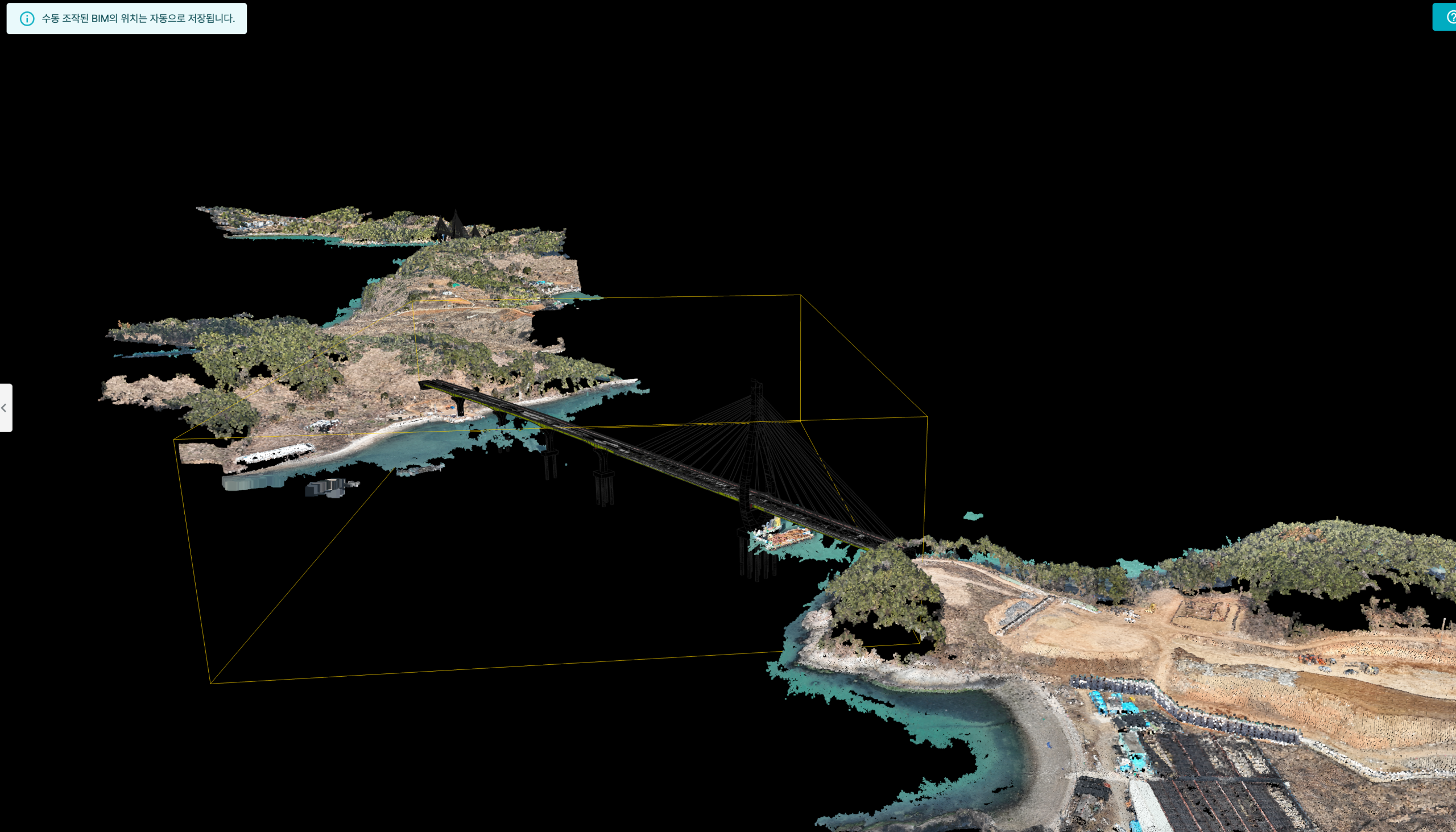
A digital twin of the Hwatae–Baekya Section 2 sea bridge site, rebuilt in 3D from drone footage. The two islands, the cable-stayed bridge, and the surrounding coastline are all faithfully reproduced.
© Meissa
Drones gave the job site eyes
In 2025, at Section 2 of National Route 77's Hwatae–Baekya crossing, off the coast of Yeosu in South Jeolla Province, a drone took to the air over a sea bridge construction site. The work spans two islands, and this was a case of aerial filming and repeated remote monitoring of that site — a proof-of-concept for "digital twin construction using an island-specialized drone station" run by contractor Kolon Global and geospatial company Meissa using DJI's Dock 3 station.
The core of it is that autonomous drone flights replaced the process and quality checks that people used to carry out by boat, going back and forth between the islands. The Hwatae–Baekya stretch in particular was notorious for difficult working conditions — sea fog and strong winds that changed constantly, and communications that weren't always reliable. Throughout the construction period, both the weekly scheduled shoots and the as-needed shoots for critical processes were all handled through unmanned monitoring.
Cutting labor and operating costs wasn't the only point. Ha Chang-seong, business team lead at Meissa, called it "a turning point that proved unmanned automated monitoring is possible at sites people struggle to reach," adding that "the path toward commercializing and generalizing drone-station unmanned monitoring is now visible." "Unmanned" doesn't just mean taking people out of the picture. It means eyes and feet can now reach places that were dangerous, or simply out of reach.
Set what you've captured against the drawings, and the gap shows itself
The principle is simple. AI reads concrete surfaces, rebar positions, and pipe routing from footage shot by a drone or a hard-hat-mounted camera. Layer that data over building information modeling (BIM) drawings, and the gap between design and reality shows up in color. A red zone is a zone with an error. What used to be a person measuring a few spots here and there with a tape measure, AI now catches without missing a spot, scanning through thousands of images. The moment an error lights up red, the response shifts from "fixing it after the fact" to "catching it on the spot."
Other countries led the way here first. In the US, Buildots and Doxel use AI to analyze site footage and automatically tally progress rates, while OpenSpace matches shot locations to drawings automatically, without GPS or physical markers — one client reportedly cut site visits in half after adopting it. At the precision end, there's Leica's autonomous-flight LiDAR scanner, and Trimble's high-precision scanner mounted on a quadruped robot. These are reference points, though — it's domestic startups that have translated this technology into the language of Korean job sites.
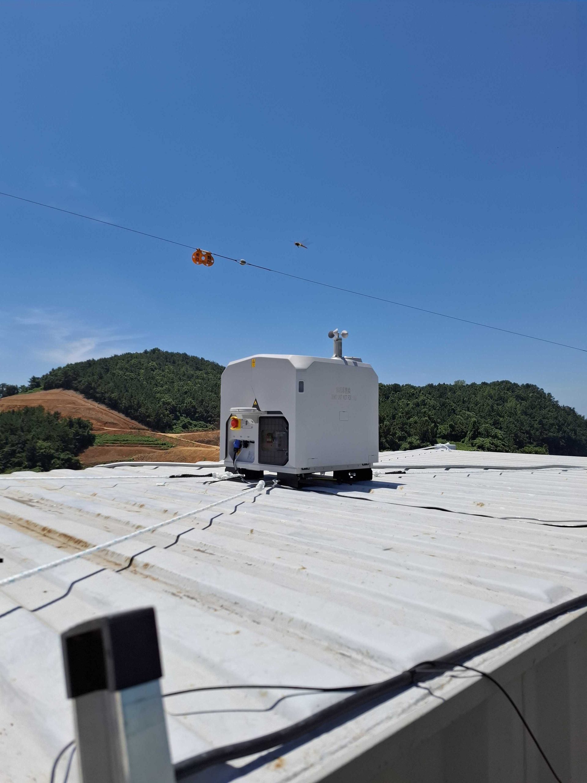
An unmanned drone station perched on the rooftop of a site building. A weather vane keeps watch on conditions.
© Meissa
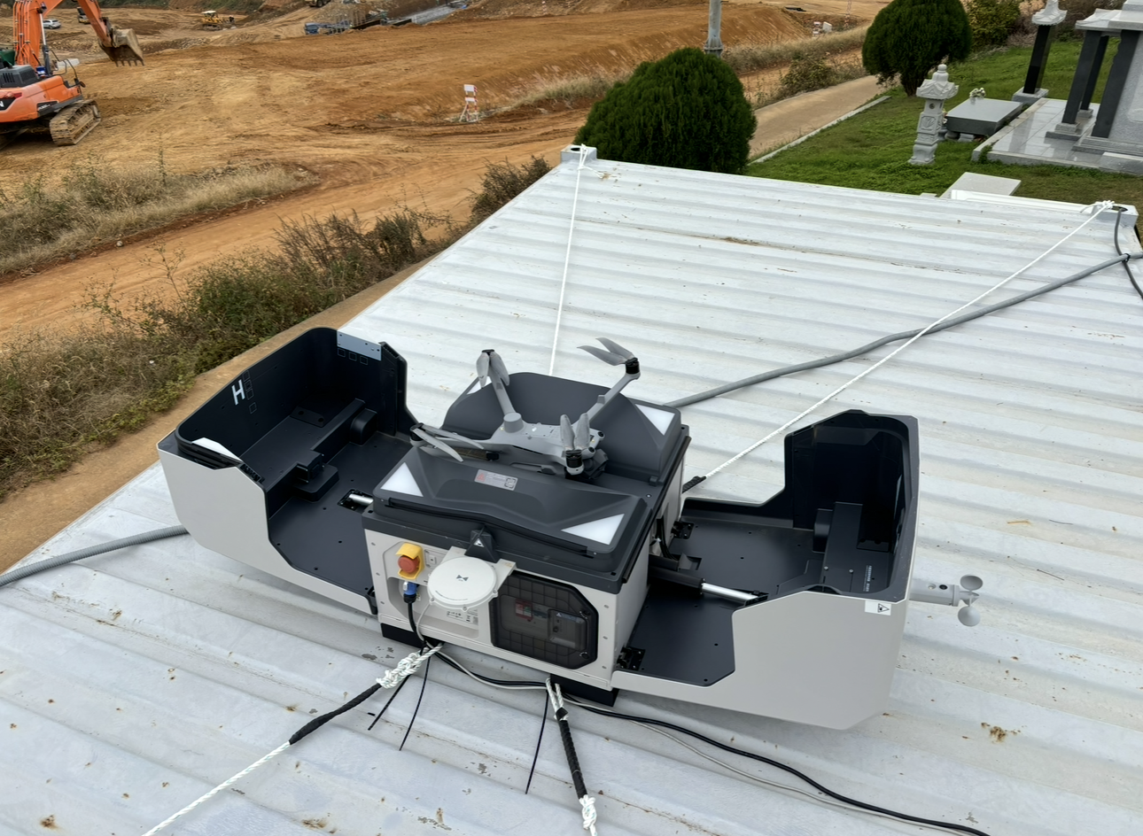
Once the cover opens, the waiting drone lifts off on its own. An earthworks site stretches out behind it.
© Meissa
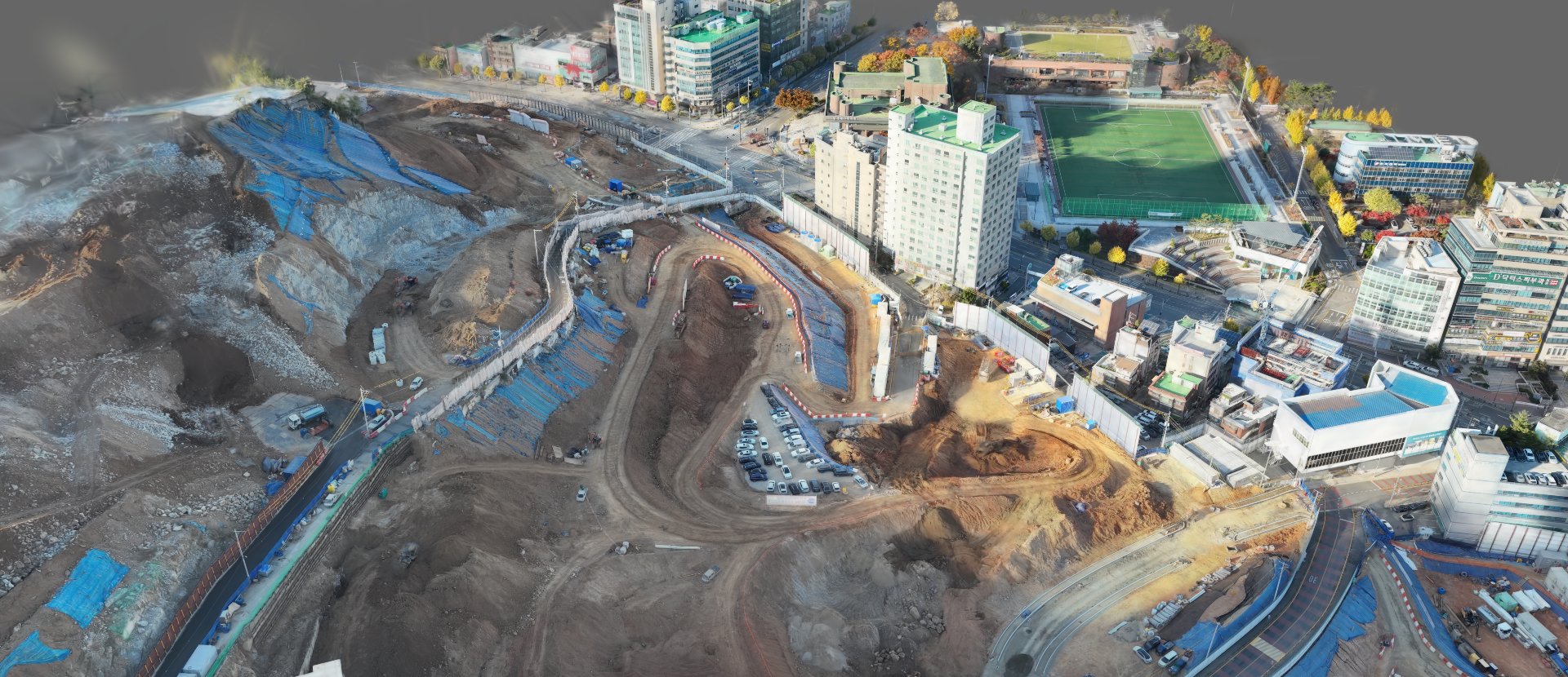
Meissa dug into earthworks sites specifically. AI analyzes drone and satellite imagery to build orthomosaics and point-cloud data, then overlays that onto BIM drawings to precisely track how much earth has been cut and filled. That cuts down on the losses that used to come from over-excavating and backfilling, or under-filling and having to redo it. The company says this approach has cut surveying costs by 90% and shrunk data processing that used to take weeks down to 10 minutes. The unmanned station at Hwatae–Baekya mentioned earlier also ran on this company's platform. Meissa has raised a cumulative 37 billion won and is preparing for a KOSDAQ listing in the second half of 2026.
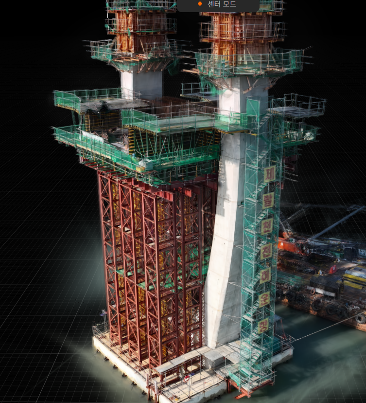
A 3D model of a sea bridge pylon, reproduced down to the scaffolding and formwork. Even high or hard-to-reach sections can be examined on screen.
© Angelswing
Angelswing is a site-virtualization platform used across civil engineering, building construction, and sea bridge projects, among others. It has expanded beyond surveying and earthwork-volume calculation into real-time remote site monitoring by drone. Set up a station on site with a drone in place, and it runs on 100% unmanned autonomous flight, taking off daily or several times a day depending on the settings to photograph the site. Because it works by regularly updating this high-precision data, it covers not just wide-open large-scale sites but dense urban construction sites too. Drone footage comes back as high-resolution 3D imagery and time-lapses, which makes it especially strong for examining and documenting sections that need close analysis or that sit high up.
Angelswing CEO Park Won-nyeong pointed to a broader shift in the market, saying "drone-based surveying on construction sites has already become the standard." At client companies using this firm's solution tied to unmanned drone stations, surveying 100 hectares dropped from two weeks to two hours, and costs fell to around 60% of what they used to be. At overseas sites, travel costs for bid preparation were cut entirely, and one case used the platform to pull earthwork-volume estimates for subcontractors, cutting costs by 50%.
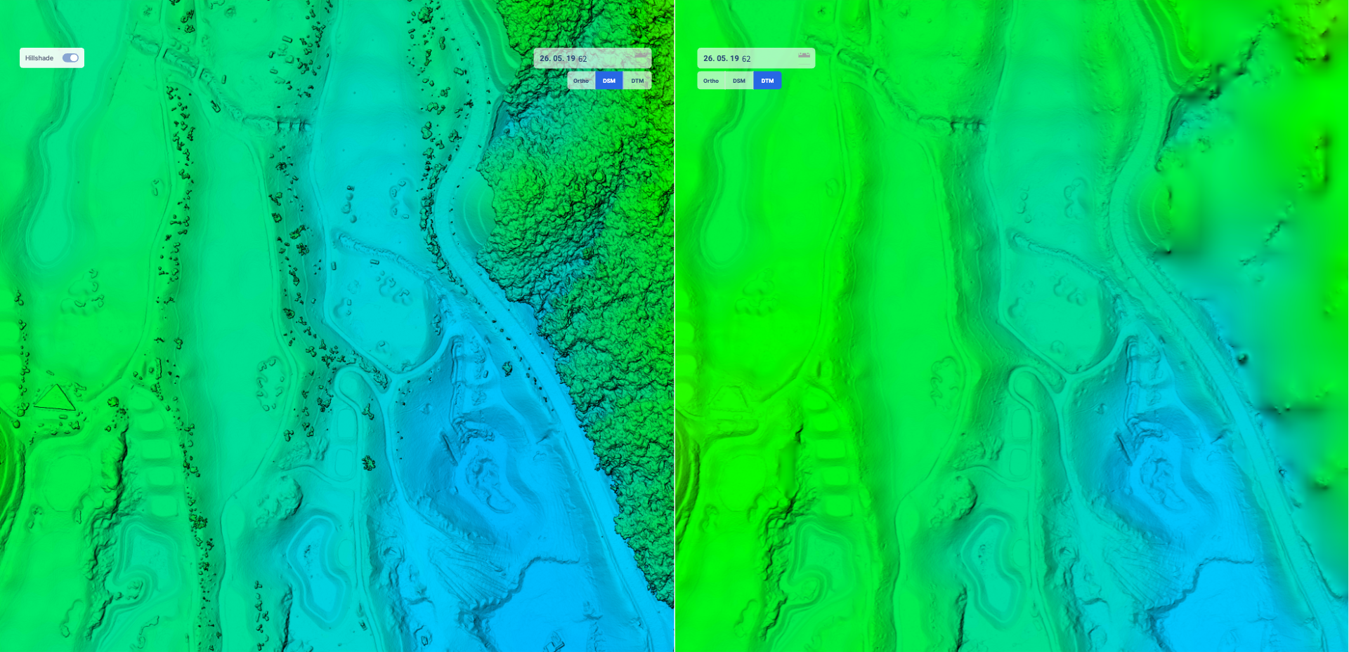
Calculating earthwork volume requires isolating the terrain alone. On the left, a surface model (DSM) that still includes obstructions like trees; on the right, a terrain model (DTM) with those obstructions automatically stripped out by AI.
© Angelswing
80% of Korea's top 20 contractors by construction capability — including Samsung C&T, GS E&C, Hyundai E&C, and CJ Logistics' construction division — use this platform. Add in ordering bodies like LH, and the total number of sites using it reaches roughly 500. He noted that "because survey data updates automatically on a regular cycle, everything from bidding to process monitoring can be managed as a single integrated dataset," and that "sites no longer have to spend their effort managing drone personnel — they can focus on expertise and safety management instead, and put the recorded site data to use." It's a clear statement of what drone use actually buys you.
The eyes don't have to be expensive, either. Cupix took the approach of strapping a 360-degree camera you can buy for around 500,000 won — something like an Insta360 or a Ricoh Theta — onto a hard hat and simply walking the site. No expensive equipment, no professional operator — just walking the site the way you normally would is enough. Whether it's a drone or a hard-hat camera, the "eyes" that turn a site into data are already commercially available. What's expensive and difficult comes after that: turning the data into meaning.
One late correction costs more than a year's subscription
The real reason site managers open their wallets for this kind of platform isn't efficiency. Cutting survey staff is a visible saving, but preventing bad construction before it happens is about eliminating a risk you can't see. Add up the direct cost of changing a design and undoing work, the resulting delays and liquidated damages, and, in rare cases, the cost of re-pouring concrete, and the math becomes obvious. A single late correction costs far more than a year's subscription to a drone platform.
The numbers have already become the language of the job site. A 100-hectare survey down to two hours, eight out of the top 20 contractors using drone data, a single hard-hat camera replicating an entire site in 20 minutes. The market is betting on this trend too. The construction and infrastructure drone data analysis market is projected to grow at close to 30% a year, roughly eightfold over eight years (SNS Insider). That's also why money keeps flowing into a scattered field of startups — Meissa has raised 37 billion won, Cupix has raised 70 billion won, and both have their sights on a KOSDAQ listing.
Where does the person who put down the tape measure go?
So where does the person who used to carry the tape measure end up? Surveying and inspection were grueling, hazardous, repetitive work — measuring the site under the blazing sun and up on scaffolding, checking it against the drawings, and measuring again if something was off. Drones and AI are taking over that repetition. But data doesn't make judgment calls on its own. Reading why a red zone appeared, deciding whether to redo the work or revise the design, figuring out where responsibility lies — that's still a person's job.
Drones see; people decide. The surveyor who set down the tape measure moves into a role reading and judging the site in front of a digital twin. New jobs are emerging — operating drones, interpreting the data that piles up, deciding how to handle each discrepancy. As people are pulled out of dangerous spots, more of them move into roles that require judgment. What's disappearing isn't the job — it's the tape measure that people used to risk their safety carrying.
Catch an error early, and there's less to fix later — and less dispute and distrust along with it. What drones protect isn't just the schedule and the budget. It's trust in what actually gets built.